
POTENTIAL MEASUREMENT AND MODELING OF ATLAS OF ARTIFICIAL ISLANDS OF WIND AND SOLAR ENERGY
DOI:
https://doi.org/10.71146/kjmr638Keywords:
Artificial Energy Islands, Offshore Renewable Energy, Wind-Solar Hybrid Systems, Geospatial Energy Modeling, Renewable Energy Potential MappingAbstract
Background:
The accelerating demand for renewable energy has pushed the frontiers of innovation toward offshore energy generation platforms. Artificial islands designed for wind and solar energy capture present a promising opportunity to harness consistent and scalable resources in marine environments. However, identifying optimal locations and ensuring technical, environmental, and economic viability remains a complex challenge.
Objective:
This study aimed to develop a comprehensive atlas of artificial island sites optimized for hybrid wind and solar energy production across key marine regions. The objective was to measure energy potential, model system performance, and assess ecological and economic impacts to support strategic offshore renewable energy planning.
Methods:
A four phase research design was implemented, integrating geospatial modeling, energy resource analysis, and environmental-economic evaluation. High-resolution datasets from global sources such as NASA SRTM, EMODnet, Copernicus, and ECMWF were used to assess bathymetry, irradiance, and wind speed over a 10-year period. Site suitability analysis was performed using ArcGIS Pro and QGIS 3.28, incorporating weighted overlay and Analytic Hierarchy Process (AHP) frameworks. Energy yield simulations were conducted using PVGIS, SAM, and Weibull-based wind modeling. Economic analysis employed HOMER Grid and MATLAB Simulink to determine Net Present Cost (NPC), Levelized Cost of Energy (LCOE), and Internal Rate of Return (IRR). Environmental impacts were evaluated using ISO 14001-compliant spatial overlays. Expert consultation with 15 domain specialists validated model assumptions and site criteria.
Results:
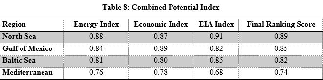
The Gulf of Mexico emerged as the most economically favorable region, with the lowest NPC ($1000M), LCOE ($0.065/kWh), and highest IRR (12.2%). The North Sea led in wind energy potential with a capacity factor of 42% and annual output of 4500 GWh, while the Mediterranean showed the highest solar yield (GHI 5.8 kWh/m²/day, 2100 GWh/year). Environmental assessments rated the North Sea as low impact, while the Mediterranean was high impact due to sensitive biodiversity zones. Sensitivity analysis showed that a 20% reduction in CAPEX for the North Sea site could lower LCOE from $0.067 to $0.058/kWh. Grid integration analyses revealed that closer proximity (North Sea: 35 km) significantly reduced transmission losses and costs.
Conclusion:
This study demonstrates the feasibility and strategic value of artificial islands for offshore wind-solar hybrid energy generation. The integrated modeling approach provides actionable insights for policymakers and investors, highlighting regions with high resource potential and manageable ecological and economic trade-offs. The developed atlas serves as a foundational tool for future offshore renewable infrastructure development, aligning with global decarbonization goals.
Downloads
Downloads
Published
License
Copyright (c) 2025 Zubeda Bhatti, Muhammad Bachal Korai (Author)

This work is licensed under a Creative Commons Attribution 4.0 International License.
How to Cite


